Building biodiversity knowledge for action in Southern Africa: spatial biodiversity assessment, prioritization and planning in South Africa, Namibia, Mozambique and Malawi.
Few African countries currently have spatial data on biodiversity to enable them to make informed decisions and policies on land use planning and biodiversity protection in their National Biodiversity Strategy and Action Plan (NBSAP), a requirement for parties to the Convention on Biological Diversity (CBD). The SBAPP Regional Project addresses this issue.
It started in July 2022, ends in June 2027 and is funded by donors the Agence Française de Développement (AFD) and the Fonds Français pour l’Environnement Mondial (FFEM). The South African National Biodiversity Institute (SANBI) is the Lead Implementing Agency, working with the following Country Implementing Agencies:
In Mozambique, MTA has assigned the National Directorate of Environment (DINAB) as the focal institution for this project to work in collaboration with WCS, similarly to what has been done in the past for COMBO program and the KBA and Red List projects. WCS’s Mozambican Program has established a joint team with DINAB for project implementation. WCS has been working over the past few years on SBAPP related activities within Mozambique, which includes the development of a national ecosystem map, assessment of species threat status, and identification of KBAs, which will be important corner stones of this project.
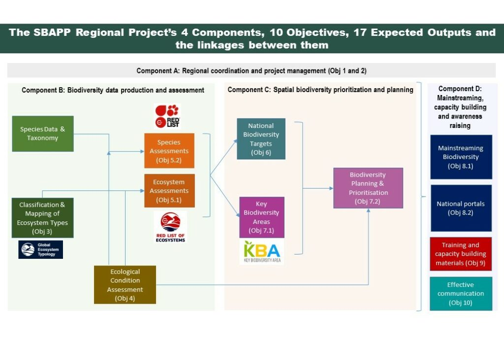
The project has 4 Components, 10 Objectives, and 17 Expected Outputs. The diagram below gives a rough idea of how the Expected Outputs of the project depend on each other. More information on the project can be found here.
SANBI link: https://www.sanbi.org/
Goals
The SBAPP Regional Project aims to develop and/or enhance national spatial biodiversity assessments, prioritization and planning (SBAPP) processes and products in four Southern African countries in order to strengthen the national knowledge base on biodiversity; and ensure this knowledge informs land use planning and decision making, assists with the development of environmental policy and strategies, and provides a basis for future biodiversity monitoring.
All four countries have a substantial number of shared species and ecosystem types across their borders, making regional cooperation vital for mapping and assessment processes.
Accomplishments
- Since May 2023, the project has supported the National Directorate for the Environment (DINAB) in updating the National Biodiversity Conservation Strategy and Action Plan (NBSAP) to align with the Kunming-Montreal Global Biodiversity Framework. WCS helped create a roadmap and establish a technical working group, which successfully submitted preliminary national biodiversity targets to the CBD Secretariat on July 31, 2024.
- On June 20, 2024, the Minister of Land and Environment launched the historical vegetation map and the national Red List of ecosystems, developed by WCS. The event, attended by over 100 participants, promoted sustainable management of the Miombo Forest and received media coverage. The technical reports and interactive map are now available in Portuguese and English on SIBMOZ ( https://sibmoz.gov.mz/ecosystems/).
- Prior to the launch, DINAB and WCS presented the mapping products at technical councils for relevant ministries, including the Ministry of Mineral Resources and Energy (MIREME) and the Ministry of Public Works, Housing, and Water Resources (MOPRH) in May 2024.
- The SBAPP project is building a citizen science community in Mozambique. Three iNaturalist training sessions were conducted, including participation in the City Nature Challenge in April 2024, where 31 participants made 422 observations of 239 species. The number of citizen scientists contributing to iNaturalist increased by 39%, from 731 in June 2022 to 1,040 in January 2024.
- Since May 2024, SBAPP has collaborated with academia and research institutes to collect biological and socio-economic data in six priority areas across Inhambane, Gaza, Manica, Tete, and Zambézia. This data will help evaluate extinction risks using the IUCN Red List, identify Key Biodiversity Areas (KBAs), and support spatial planning for biodiversity.